I've been reading a thread on GPS navigators etc ...
Why would you spend $700 on a Hema navigator when you can use the iPad or Android tablet apps?
There must be some compelling reasons?
Cheers
Luke
Mapping software ...
Moderators: krp102, Coxy68, robcaz
Mapping software ...
--
Cheeers
Luke JP (Qual) : VK4KYT
Cheeers
Luke JP (Qual) : VK4KYT
-
OldBikerPete

- Posts: 6
- Joined: Wed Feb 12, 2014 10:47 am
Re: Mapping software ...
The only rational reason I can think of is that then you can use Hema's (very good) maps.Prime wrote:I've been reading a thread on GPS navigators etc ...
Why would you spend $700 on a Hema navigator when you can use the iPad or Android tablet apps?
There must be some compelling reasons?
Cheers
Luke
I am a 4WD club member and past president and prefer to primarily use OziExplorer on a 10" Android tablet. That program has very good map availablity and also the ability for one to calibrate scans of paper maps and/or aerial photographs. I also use other mapping programs (CoPilot - for turn-by-turn spoken navigation on roads, 'Locus Pro' for additional off-road maps and 'Pocket Earth' for more off-road mapping).
The Android is also a useful traveller's companion in that it can run programs useful when on the road.
There's 'Cool Reader' for reading electronic books (I have a library of an extimated 50,000 books on the tablet).
There's 'The Photographer's Ephemeris' for plotting the rise and set of both sun and moon against a map background.
There's 'WinAmp' for playing my hundreds of tracks of music through the car radio via bluetooth.
There's 'Photo Gallery' and 'MX Player' for inflicting photos of the grandkids on anyone foolish enough to show the slightest interest.
There's 'WiFi File Transfer' for moving files between the tablet and a PC, 'Skype' for keeping in touch with family.
It's a no-brainer, I feel.
Peter.

Re: Mapping software ...
We have no room in the limited cabin of the JK Wrangler Jeep for an ipad, even infront of the radio it would block the aircon outlets. The ipad needs to be positioned so in the event of an accident no one wears it when the air bags go off.
The only safe place I could find for our Hema Navigator was above the mirror
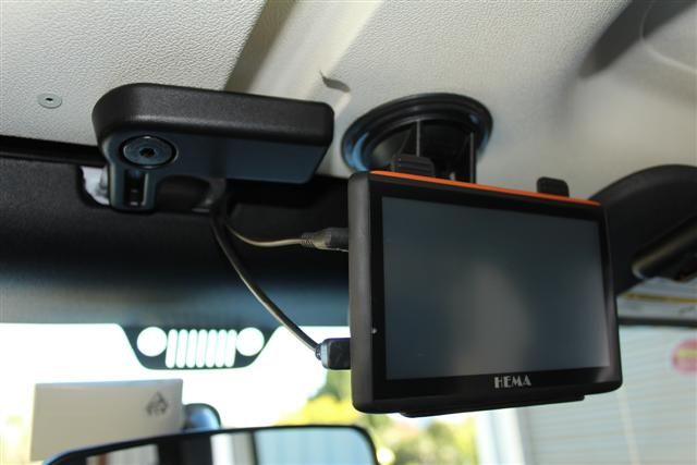
We use our map book to plot our course & the Hema to follow the route.
The only safe place I could find for our Hema Navigator was above the mirror
We use our map book to plot our course & the Hema to follow the route.
happy camping
Rob & Carol
Australian CamperTrailers Group co-owner
We're just two lost souls swimming in a fish bowl, year after year
Rob & Carol
Australian CamperTrailers Group co-owner
We're just two lost souls swimming in a fish bowl, year after year
Re: Mapping software ...
Seems to me that you've come up with the same rationale that I had ...
Seems the tablet is much more versatile in general terms plus it has the maps ... We have a garmin GPS that we can use for turn by turn navigation, but oziexplorer seems the way to go from my perspective to.
luke
Seems the tablet is much more versatile in general terms plus it has the maps ... We have a garmin GPS that we can use for turn by turn navigation, but oziexplorer seems the way to go from my perspective to.
luke
--
Cheeers
Luke JP (Qual) : VK4KYT
Cheeers
Luke JP (Qual) : VK4KYT
-
Ern_Reeders
- Posts: 62
- Joined: Wed Feb 19, 2014 2:16 pm
- Location: Melbourne
Re: Mapping software ...
I'd say folk like the Hema because it's a one package solution.
I run a Garmin with Oztopo v6. Those maps have the scale that suits my needs, & I can move the SD card to the handheld when on foot.
I run a Garmin with Oztopo v6. Those maps have the scale that suits my needs, & I can move the SD card to the handheld when on foot.
Cheers, Ern
Pioneer Argyle SE and Isuzu MU-X
Pioneer Argyle SE and Isuzu MU-X