I am looking to replace my old GPS unit.
I thought I would upgrade to a unit with 4wd maps.
Not sure which one to buy, the favoured unit is the Hema 7 . A good unit but is around $700,a bit more that I wanted to spend.
Polaris has a unit for abt $400.
What unit do you guys use? Are 4wd maps worth the extra expense.
Thanks
Jeff
Advice on GPS
Moderators: krp102, Coxy68, robcaz
Re: Advice on GPS
I use an ipad mini with Hema maps. Absolutely love it. Have a Ram mount on the dash. One big advantage of the ipad is you can also use it for photos, emails, web surfing etc. The Hema 4x4 app is only $129 with all the maps. Buy some itunes cards from Coles @ 20% off and save.
Tink
Tink
-
OldBikerPete

- Posts: 6
- Joined: Wed Feb 12, 2014 10:47 am
Re: Advice on GPS
Look for a general-purpose Android tablet computer with an in-built GPS unit. They are available from about $250 for a 10" unit but smaller units are available. You can then load Apps of all sorts including Locus Pro, OziExplorer, Copilot to name just a few of the mapping variety, plus apps like Winamp which, in combination with bluetooth or a transmitter plugin for the the earpiece socket can play hours of your music through your car's radio.
It's a much more versatile way to go than getting a dedicated GPS unit.
I have had such a unit for over 12 months and am extremely pleased with its performance.
Peter.
It's a much more versatile way to go than getting a dedicated GPS unit.
I have had such a unit for over 12 months and am extremely pleased with its performance.
Peter.
Re: Advice on GPS
Thanks for the info.
The tablet idea is good. Would I need to have a SIM card to access the internet and GPS .
Jeff
The tablet idea is good. Would I need to have a SIM card to access the internet and GPS .
Jeff
Re: Advice on GPS
I have an in dash VMS unit which is great, but for backup and when I am out of the car, I have an 8" Samsung tablet ($288 but the 7" is a cheaper) running Oziexplorer for Android which is a free down load and $25 for a license. Works an absolute treat. The advantage for me was I already own a stack of Ozi maps (maps are $199 I think). For about $450 you get a pretty good system. When I want to access the internet I tether the tablet to my iPhone 4s via the iPhone's wireless hot spot using bluetooth and use the iPhone's 3g connection. Best of both worlds and reasonably inexpensive. Terry

Re: Advice on GPS
Hi Jeff,
The two seven inch screen navigators that are most commonly used & combine both street & topo maps in the one portable unit are made by Hema & VMS. Both use iGO Primo street navigation.
It really comes down to your personal preference between the off road maps & mapping software used. VMS uses Gregory's touring, iTOPO 4X4 raster & state Westprint Heritage series maps while Hema uses the Hema Australia 4WD raster collection, 4WD and regional, 1:1million Australian touring & topo 250K maps.
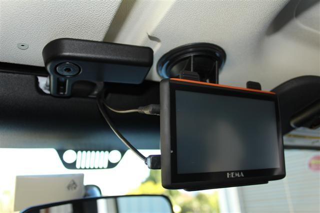
We went for the Hema HN5i a couple of years ago as we have a Hema map book & the Camps Australia Wide books also use Hema maps so we could easily relate between them. We mostly use the Hema to show where we are on a 4wd track in relation to the map, while we still use the map book for the overall picture. There is not a lot of room in the cab of the Jeep Wranger & also with a very narrow windscreen having anything there blocks plenty, I have managed to place the suction mount on the roof above the rearview mirror & out of the way.
The trend these days is to download the Hema maps App to iPads. There are two different versions, the Hema Explorer & 4WD Maps
Your iPad also needs an inbuilt GPS function for the App to work. Kevin Beckwith will be giving a talk on the Hema App at the upcoming national meet.
Probably the only down side of using an Ipad in a smaller cabin area is the available space without blocking the view of the dash controls & also allowing room for the airbag deployment. There are a number of cradles & different mounting solutions. I think these flex rods bolted to the seatbase are a good idea.
The two seven inch screen navigators that are most commonly used & combine both street & topo maps in the one portable unit are made by Hema & VMS. Both use iGO Primo street navigation.
It really comes down to your personal preference between the off road maps & mapping software used. VMS uses Gregory's touring, iTOPO 4X4 raster & state Westprint Heritage series maps while Hema uses the Hema Australia 4WD raster collection, 4WD and regional, 1:1million Australian touring & topo 250K maps.
We went for the Hema HN5i a couple of years ago as we have a Hema map book & the Camps Australia Wide books also use Hema maps so we could easily relate between them. We mostly use the Hema to show where we are on a 4wd track in relation to the map, while we still use the map book for the overall picture. There is not a lot of room in the cab of the Jeep Wranger & also with a very narrow windscreen having anything there blocks plenty, I have managed to place the suction mount on the roof above the rearview mirror & out of the way.
The trend these days is to download the Hema maps App to iPads. There are two different versions, the Hema Explorer & 4WD Maps
Your iPad also needs an inbuilt GPS function for the App to work. Kevin Beckwith will be giving a talk on the Hema App at the upcoming national meet.
Probably the only down side of using an Ipad in a smaller cabin area is the available space without blocking the view of the dash controls & also allowing room for the airbag deployment. There are a number of cradles & different mounting solutions. I think these flex rods bolted to the seatbase are a good idea.
happy camping
Rob & Carol
Australian CamperTrailers Group co-owner
We're just two lost souls swimming in a fish bowl, year after year
Rob & Carol
Australian CamperTrailers Group co-owner
We're just two lost souls swimming in a fish bowl, year after year
-
OldBikerPete
- Posts: 6
- Joined: Wed Feb 12, 2014 10:47 am
Re: Advice on GPS
You don't need a SIM to use the GPS or GPS apps.thommo19 wrote:Thanks for the info.
The tablet idea is good. Would I need to have a SIM card to access the internet and GPS .
Jeff
Most tablets have WiFi which would allow you to access the internet at home (if you have a WiFi router at home) or in a lot of public places (Macca's) and caravan parks these days.
There's an app which allows you to download files from your internet browser on a desk or laptop computer via WiFi.
My tablet also accepts a 3G SIM for voice and data access.
Bluetooth is also useful if you have a bluetooth earpiece for 'phone use or bluetooth capability in your car radio.
You can also surf the net on it via WiFi or that 3G SIM -- you can do lots of things with it, it's a general-purpose computer.
Here's where I got mine from:
http://efocuszone.com/
Peter
Re: Advice on GPS
Hi Jeff,
Have a look at Kev's reply in this thread for more info http://www.campertrailers.org/group/vie ... p?f=1&t=93
Have a look at Kev's reply in this thread for more info http://www.campertrailers.org/group/vie ... p?f=1&t=93
happy camping
Rob & Carol
Australian CamperTrailers Group co-owner
We're just two lost souls swimming in a fish bowl, year after year
Rob & Carol
Australian CamperTrailers Group co-owner
We're just two lost souls swimming in a fish bowl, year after year
Re: Advice on GPS
Thanks for all the advice .
I will have a look at the ipad app at Newnes
thanks again
Jeff
I will have a look at the ipad app at Newnes
thanks again
Jeff
-
Markwr400426

- Posts: 24
- Joined: Fri Apr 04, 2014 9:39 pm
- Location: Wishart Brisbane
- Contact:
Re: Advice on GPS
For the trailbike, I run a Garmin Dakota on the bars, and I've put Shonky Maps topo map as the map. A small example is here: [img][IMG]http://i792.photobucket.com/albums/yy20 ... artial.jpg[/img][/img] I've only put up a small sample, but hopefully you'll get the idea. If I'm going somewhere new, I'll just load the maps for that area into the Dakota. Shonkymaps is a 340Mb download, it's free and here: http://shonkylogic.net/shonkymaps/. It's great to be able to use a topo map to look at where you've been, or plan where you want to go, without parting with a fortune for the maps. From a 4WD perspective, you could throw Shonky Maps into a laptop, or maybe an iPad. Either that, or go for a larger Garmin GPS, and put ShonkyMaps into that using either of the Garmin mapping programs, like Garmin MapSource or Garmin Base Camp. Once you've got a track logged in the GPS, it's not too hard to bring it into Google Earth to give you a better understanding again of where you've been. I've spent a fair bit of time in the South East Queensland State forestries, North Stradbroke Island, Fraser Island & Double Island Point, and using the GPS has helped build a pretty good understanding of where I've been. The GPS has also been pretty helpful in finding a way through somewhere to link some tracks together.
Mark
![[IMG]http://i792.photobucket.com/albums/yy20 ... artial.jpg[/img]](http://s792.photobucket.com/user/Markwr400426/media/KW130329partial.jpg.html)
Mark
Lifestyle 360 softfloor
Nissan Patrol 4.8 LPG
Nissan Patrol 4.8 LPG